Skip to content
Cyclist climbing Dalsnibba above the UNESCO Geirangerfjord on the Norway 3-day Geiranger trip

Western Fjords 3-Day Cycling Trip — Hard

Base location: Geiranger
363 km6,751 m3 days

Written by Tommy NielsenCycling guide based in Norway

This itinerary reflects my own riding on Western Fjords

Who is this trip for?

  • Comfortable with 100 km days at 1,500–2,500 m elevation
  • Looking for a mix of climbing icons and recovery
  • First-time Western Fjords cyclist with no reference rides

Before your trip

Two nights in Geiranger at Havila Hotel by the fjord. Arrive Friday afternoon, ride Saturday and Sunday, then check out Monday morning and drive 1 hour to Hjelle for Day 3 before heading home. The trip pattern is the same as the Sognefjord 3-day: ride from a single base for the heavy days, then turn the final morning into a scenic departure rather than a third hotel check-in.

Geiranger sits at the head of the UNESCO-listed Geirangerfjord — the most photographed fjord in Norway, with the Seven Sisters waterfall on one side and Bridal Veil on the other. From the village the road climbs in every direction. Dalsnibba straight up, Trollstigen via the Eagle Road and a short ferry, and the Gamle Strynefjellsveg an hour west by car. Three of Norway's most distinctive mountain roads in three consecutive days.

Day 1 (Saturday) is Dalsnibba and the Hellesylt ferry. 162 kilometres, 2,511 metres of climbing — the first kilometres of Dalsnibba sit close to 8% and the final 4.5 km to the plateau averages 9.5%. Brutal is the right word. Then a descent on the historic Gamle Strynefjellsveg, lunch at Gamlebutikken på Hjelle by Oppstrynsvatnet, a stop in Stryn to stock up on inner tubes (no bike shops between here and Geiranger), and the UNESCO Hellesylt-Geiranger ferry to close the day. Sit on the roof deck. Order a svele.

Day 2 (Sunday) is Ørnevegen plus Trollstigen. 159 kilometres, 3,230 metres — two iconic climbs in one ride. Ørnevegen out of Geiranger is 6.9 km at 8.2% with 11 hairpins; Trollstigen on the far side of the Eidsdal ferry is 7.9 km at 8.2%. Hot, exposed, spectacular — drivers gave thumbs up as we climbed. Eidsdal ferry sveler are a tradition; the Trollstigen summit café is mandatory; Gudbrandjuvet on the way back has the only toilets you'll find for a long stretch.

Day 3 (Monday) starts with a 1-hour drive from Geiranger to Hjelle — the gateway to one of Norway's historic mountain roads. It's fully possible to ride there — Gamle Strynefjellsveg can be reached via Dalsnibba, and we descended it on Day 1 — but when Day 3 focuses on the climb itself, the car saves the legs. From Hjelle the climb is honest: a gentle 7 km out of the village before the road tilts up to 7-8% and stays there for the next 11 km to the 1,098-metre summit. Rough asphalt all the way. No cafés, no service — just the road, the mountains and the snow patches lingering on the peaks even in August. Lunch at Gamlebutikken på Hjelle after the descent before the drive home. Hjelle Hotell on Oppstrynsvatnet is a practical accommodation option if you want to split the return — we've stayed there ourselves.

Each day's route has its own full guide on this site with elevation profile, GPX download and kilometre-by-kilometre breakdown. Use the trip page as the structure; use each route page as the field reference.

Distance
363 km
Elevation
6,751 m
Days
3 days
Difficulty
Intermediate
Best months
July, August, September
Base location
Geiranger

Trip overview map

Map loads when you scroll here.
  • Day 1:Queen
  • Day 2:Queen
  • Day 3:Hard

5-day itinerary

Cycling Dalsnibba from Geiranger — HC climb above the UNESCO Geirangerfjord, Norway
1
Day 01 / 03
Queen StageGeiranger — Dalsnibba HC

Dalsnibba HC + UNESCO Hellesylt ferry

Distance
162km
Elevation
2,511m
Profile

162 km / 2,511 m. From sea level in Geiranger up to the Geiranger Skywalk at 1,500m — 21 km at 7% with the final 4.5 km averaging 9.5%. Then a descent on the historic Gamle Strynefjellsveg (asphalt, with a short gravel plateau at the top), lunch at Gamlebutikken på Hjelle by Oppstrynsvatnet, through Stryn, Hornindal, and the UNESCO Hellesylt-Geiranger ferry to close the day. A full day in the saddle and a fjordeventyr to finish.

🌧 Plan B for rain
If the Dalsnibba summit is socked in, ride it anyway — the climb is the climb regardless of view. If the rain is heavy, swap Day 1 with Day 3: drive to Hjelle for Gamle Strynefjellsveg (lower exposure), and take Dalsnibba on the better day.

We were up early in Geiranger, knowing what was waiting. A solid breakfast at the hotel, wet asphalt outside, light rain that cleared up as we rolled out of the village. Dalsnibba starts climbing from the first pedal stroke. There is no warm-up here — the road tips upward and stays that way for 21 kilometres.

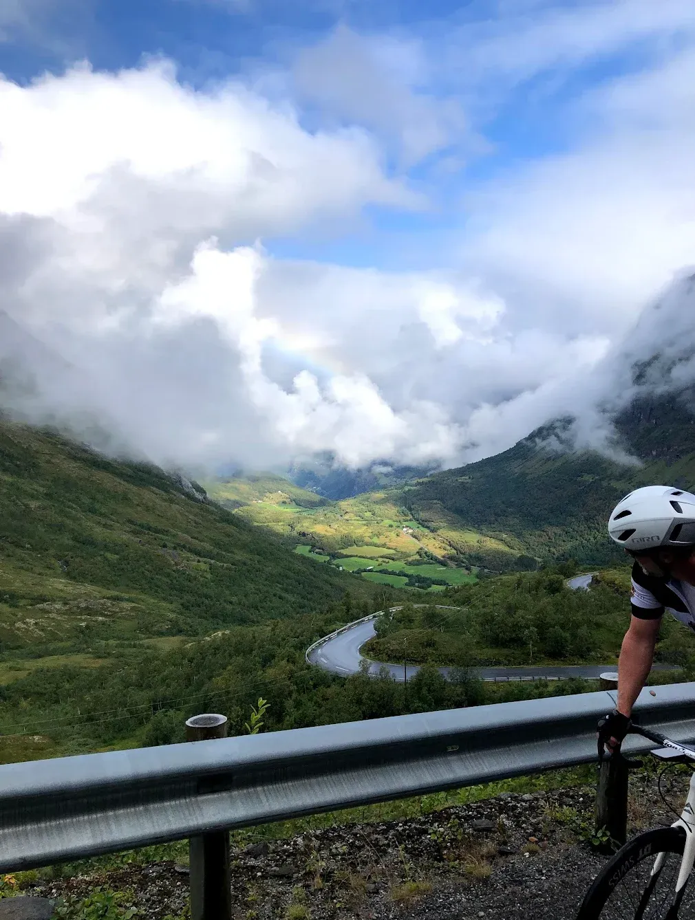
The first kilometres sat close to 8%. We pushed through the lower section with mystical clouds rolling around us — visibility shifting from full panorama down the Geirangerfjord to grey-white mist and back again, sometimes within a single hairpin. Good views down to the fjord most of the way up. The road kept tilting.

The final 4.5 kilometres to the Dalsnibba plateau averages 9.5%. Fryktelig bratt. We climbed in our easiest gears, side by side, breathing hard. At the top: cloud, no view, nothing visible from the Skywalk platform. "Så ikke en dritt — må ta denne på ny," I said. The climb is worth it regardless. Come back another day for the panorama.

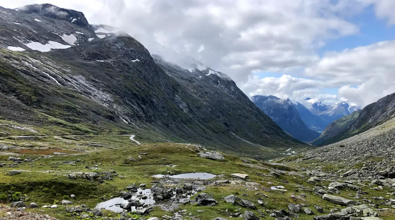
The descent on Gamle Strynefjellsveg was the surprise of the day. A short gravel plateau at the top before the road tipped over, then asphalt the whole way down — dramatic switchbacks, the kind of road that has not changed since 1894. We dropped down toward Hjelle and Oppstrynsvatnet — and the lake was there in full sun, turquoise and impossible, with snow-capped peaks behind. Lunch at Gamlebutikken outside in shorts. A different day from the cloud above.

A spin through Stryn, Hornindal for quiet scenic roads with almost no traffic, and the Hellesylt ferry waiting at the quay. The Hellesylt-Geiranger crossing is one of the most spectacular in Norway — a UNESCO World Heritage fjord, the Seven Sisters and Bridal Veil waterfalls visible from deck. We sat on the roof, ate a svele each, drank cola, and watched the same mountains we had ridden over slide past at water level. A fitting end to a hard day.

Trollstigen cycling — eleven hairpins on Norway's Geiranger–Trollstigen Scenic Route
2
Day 02 / 03
Queen StageTrollstigen — 11 Hairpins

Ørnevegen + Trollstigen double

Distance
159km
Elevation
3,230m
Profile

159 km / 3,230 m. Two iconic climbs in one day. Out of Geiranger up Ørnevegen (6.9 km at 8.2%, 11 hairpins) with Eagle Bend at the top, ferry across at Eidsdal-Linge with sveler, then Trollstigen (7.9 km at 8.2%) up its 11 famous hairpins to the summit café. Hot, exposed, and spectacular — drivers gave thumbs up as we climbed.

🌧 Plan B for rain
If the wind is up at the Trollstigen summit, ride only the Ørnevegen out-and-back from Geiranger (~30 km) and skip the second climb. Save Trollstigen for a still day — it is too exposed when the wind is honest.

Solid breakfast at Havila Hotel Geiranger, dagens første ferge already at the quay, brilliant sunshine. We rolled the 200 metres of warmup out of the harbour and Ørnevegen started right there — no easing in. 6.9 km at 8.2% average. Several groups around us: tydelig at ikke alle var klar over hva som ventet.

11 serpentiner up the wall of the fjord, the road carved into the mountainside, every switchback opening up a new view down to Geiranger. The final hairpin is Ørnesvingen — Eagle Bend — the widest of the lot, with the cruise ships in the fjord reduced to dots and Dalsnibba visible across the valley. We saved the photo stop for the descent.

The descent of Ørnevegen was the surprise of the day for the wrong reason. Bremser så varme — the brakes got hot enough that I had to stop and let them cool. Take it easy on the way down. At Oppskredtunnelen we took the gravel track on the side, recommended over the unlit tunnel. Then the Eidsdal ferry: svele tradition, brunost or smørkrem, both correct. Slak utforkjøring from the top down to the quay.

Stille veier toward Trollstigen, sauer på veien, sheep that did not move for cyclists. 30 km of slak stigning where the landscape just keeps getting more beautiful. The summit at 858m: a waffle and a coffee at the café, looking down the 11 hairpins we were about to climb. Klatringen was 7.9 km at 8.2% with 672m of elevation. Hot, sweat in my eyes, and the drivers passing me on Trollstigen kept giving thumbs up out the window. That is what climbing Trollstigen is.

Gudbrandjuvet on the way back: toilet and café, both useful. Another svele on the return ferry. Back to Havila Hotel by evening, legs cooked.

Cycling Gamle Strynefjellsveg from Hjelle — historic mountain road above Oppstrynsvatnet, Norway
3
Day 03 / 03
HardGamle Strynefjellsveg

Gamle Strynefjellsveg — historic mountain road

Distance
41.9km
Elevation
1,075m
Profile

41.9 km / 1,075 m. Day 3 starts with a 1-hour drive from Geiranger to Hjelle — the gateway to one of Norway's historic mountain roads. From Hjelle the climb is gradual for 7 km then settles in at 7-8% for the next 11 km to the 1,098m summit. Rough asphalt all the way, no cafés or service on the climb itself. Lunch at Gamlebutikken på Hjelle after the descent before driving home.

🌧 Plan B for rain
If the upper Strynefjell is closed by snow or fog (possible into early July and from September), ride only the lower 7 km out-and-back from Hjelle and call it a recovery spin. Lunch at Gamlebutikken either way.

We packed up at Geiranger after breakfast, loaded the bikes onto the car, and drove the hour west to Hjelle. Hjelle Hotell sits on the shore of Oppstrynsvatnet — we parked at the hotel and walked across to Gamlebutikken to fill bottles and pockets. There is no service on the climb itself.

The Gamle Strynefjellsveg starts climbing the moment you turn onto it. Rough asphalt from kilometre zero. The first 7 km are gradual — 0.4 to 4% — but you feel the road tilting under you the whole way. Then from kilometre 8 the gradient settles in: 6.5%, 7%, 8%. Eleven kilometres without a single recovery section. You find a rhythm, or you suffer.

Snow patches on the peaks even in August. Coarse surface, not gravel, but it has been there a long time.

The final kilometres are the steepest of the climb. We stopped at the top, took photos, and turned around. The only gravel section is a small plateau there before the descent — compact, undramatic on 25 mm tyres. No café up here, no service. Just the road and the mountains. The descent is the same 18 kilometres in reverse, with Oppstrynsvatnet reappearing turquoise below.

Back at Hjelle: lunch at Gamlebutikken in the sun, the lake glasslike, the same peaks visible above with snow still on them. Then load the bikes and drive home. Or — if you have the time — stay another night at Hjelle Hotell on Oppstrynsvatnet. Sauna, swim in the glacial lake. We've stayed there ourselves.

Download GPX files

Frequently asked questions

When is the best time for this trip?

July through early September is the climate window. Trollstigen typically opens mid-May to early June depending on snow conditions; Dalsnibba opens around the same time; Gamle Strynefjellsveg is the latest of the three to clear, usually not before July. Late June and early September are the quiet sweet spots — passes fully open, fewer tourists, daylight still long enough for big mountain days.

For the full breakdown, see When does Trollstigen open?

Where should I stay?

Two nights in Geiranger — Havila Hotel Geiranger is the natural cyclist base, fjord-side at the harbour, breakfast big enough to fuel a Trollstigen day. Geiranger has limited accommodation so book early, especially for the July-August window. For Day 3, Hjelle Hotell on Oppstrynsvatnet is a good accommodation option — we've stayed there ourselves, and it's a practical alternative if you want to split the return or start Day 3 directly from the mountain rather than from Geiranger.

Do I need a car?

Yes. Day 3 (Gamle Strynefjellsveg) starts with a 1-hour drive from Geiranger to Hjelle. It's fully possible to ride there (Strynefjellsveg can be reached via Dalsnibba — we descended it on Day 1), but when Day 3 focuses on the climb itself the car saves the legs. Most cyclists arrive by air to Ålesund or Bergen, then drive to Geiranger with bikes on roof racks or in the boot. A car also helps with grocery runs and the ferry crossings on Day 1.

How fit do I need to be?

Strong. The first two days are 162 km / 2,511 m and 159 km / 3,230 m respectively — Tommy rode hard on both Trollstigen and Ørnevegen and finished hot. Most cyclists who attempt this trip come with multiple seasons of mountain riding behind them. If 2,500+ metres of climbing in one day is new territory, ride a less aggressive Norwegian trip first.

How does this compare to the Sognefjord 3-day?

Different sport. The Sognefjord trip is heavier (305 km / 6,475 m, with Day 1 at 4,134 m in one ride) but has a single base in Skjolden and a more remote feel. The Geiranger trip is shorter on Day 3 (41 km vs 33 km), shares two days with iconic tourist roads (Dalsnibba, Trollstigen) so traffic is heavier in summer, and the ferry crossings are part of the experience. Both are hard. Most strong cyclists ride one, then go back for the other.

For the full breakdown, see Sognefjellet vs Trollstigen — which to ride first

What gearing do I need?

A compact 50/34 chainset with at least an 11-32 cassette is the practical minimum. Stronger climbers run 50/34 with 11-30. The make-or-break ratios are the final 4.5 km of Dalsnibba on Day 1 (9.5% averaged), the upper Trollstigen ramps on Day 2 (10% sections), and the sustained 7-8% of Gamle Strynefjellsveg on Day 3. On a 2,500-metre Day 1 the gear that lets you stay seated and aerobic for hours is the gear to ride.

Are the ferries part of the cost?

Yes — the Hellesylt-Geiranger UNESCO ferry on Day 1 (~1 hour) and the Eidsdal-Linge ferry on Day 2 (short crossing) are both paid. Cyclists travel cheaper than cars but it adds up. Sveler are sold on every ferry — brunost or smørkrem, both correct. Order one. The ferry is the rest stop.

Related Western Fjords content

Have you ridden this trip? I'd like to hear how it went — drop me a note.

Send a note