Skip to content
Cyclist climbing Sognefjellet from Skjolden on the Norway 3-day Sognefjord trip queen stage

Western Fjords 3-Day Cycling Trip — Hard

Base location: Skjolden
305 km6,475 m3 days

Written by Tommy NielsenCycling guide based in Norway

This itinerary reflects my own riding on Western Fjords

Who is this trip for?

  • Comfortable with 100 km days at 1,500–2,500 m elevation
  • Looking for a mix of climbing icons and recovery
  • First-time Western Fjords cyclist with no reference rides

Before your trip

**Base yourself in Skjolden for two nights.** Arrive Friday afternoon, ride Sognefjellet on Saturday, Lustrafjord and Nigardsbreen on Sunday. Monday morning, drive to Aurland (1h50 including the Mannheller-Fodnes ferry) for the Snow Road climb before heading home. The whole trip is built around two nights in one base — no luggage to move, no transfer day, no logistics to think about between rides — plus a final-morning drive that turns Day 3 into a scenic departure rather than a third hotel check-in.

Skjolden, the village at the head of Lustrafjord, has quietly become one of Norway's best small cycling bases. The shape of the trip is honest about what you're here for: one of Europe's hardest one-day rides on Day 1, a long but mostly flat fjord loop on Day 2 to give the legs a chance to come back, and a scenic mountain road on Day 3 with the practical reality that Aurlandsfjellet is a drive away — presented as part of the day's plan, not hidden in a footnote.

Day 1 (Saturday) is Sognefjellet and Tindevegen back-to-back. 129 kilometres, 4,134 metres of climbing — heavier in vertical than most queen stages on Mallorca or the Costa Blanca, in a single ride. The Sognefjellet half is a four-hour HC climb out of Fortun toward Sognefjellshytta; the Tindevegen half adds 15 hairpins out of Årdal that on a 30°C August day will empty your bottles before you reach the top. Tya Bakeri in Årdal between the two halves — giant baguette, the largest cinnamon bun in the country — is not optional.

Day 2 (Sunday) is the recovery day, but at 143 kilometres around Lustrafjord it earns the quote marks. Glacier-green water on the right, almost no traffic, two unlit tunnels (bring lights — see the Day 2 narrative for the episode that taught us this rule), the Ornes-to-Solvorn ferry as the natural mid-ride pause, Urnes stave church from 1130, and Nigardsbreen glacier at the inland end of the day. One real climb only — 15 minutes at 6.5%, and the legs from Day 1 will let you know it.

Day 3 (Monday) is Aurlandsfjellet's Snow Road. Check out of Skjolden after breakfast, load the bikes onto the car, and drive 1h50 (including the Mannheller-Fodnes ferry) to Aurland. **This is non-negotiable — Aurlandsfjellet doesn't connect to Skjolden by bike inside a sensible day's effort.** From Aurland the climb is honest: 7.2 km at 7.8% average to Stegastein, then onto the alpine plateau where the road shifts character entirely from switchbacks to long straights with sheep on the asphalt and snow patches lasting into August. Marianne Bakeri og Kafe at the fjord-side after the descent is the right way to close the trip before heading home.

Each day's route has its own full guide on this site with elevation profile, GPX download and kilometre-by-kilometre breakdown. Use the trip page as the structure; use each route page as the field reference.

Distance
305 km
Elevation
6,475 m
Days
3 days
Difficulty
Intermediate
Best months
June, July, August, September
Base location
Skjolden

Trip overview map

Map loads when you scroll here.
  • Day 1:Queen
  • Day 2:Rest
  • Day 3:Hard

5-day itinerary

Cycling up Sognefjellet from Skjolden — Northern Europe's highest mountain pass above Sognefjorden
1
Day 01 / 03
Queen StageSognefjellet & Tindevegen — Norway's Highest Mountain Roads

Sognefjellet & Tindevegen — 4,134 m in one day

Distance
129km
Elevation
4,134m
Profile

129 km / 4,134 m. Two HC climbs back-to-back from Skjolden — Sognefjellet north out of Fortun to Sognefjellshytta at 1,434 metres, then the Tindevegen pass out of Årdal with 15 hairpins followed by long straight ramps. Tya Bakeri in Årdal between the two halves is the regroup. Heavier in vertical than most queen stages elsewhere in Europe — eat well at breakfast and again at every stop. The reason this trip is rated "hard".

🌧 Plan B for rain
Don't ride Sognefjellet in fog or rain. The descents are long, exposed and unforgiving — and the Tindevegen north face holds wind. Move the day to whichever of the next two has the best window.

We woke early in Skjolden, the kind of morning where everyone is quiet because everyone has read the elevation profile. 4,134 metres in one day. You don't ease into a day like that — you just start.

The road out of Skjolden rolls flat to Fortun, and then Fortun lifts off the floor of the fjord and starts climbing the mountainside. This is where the HC begins. The first eleven kilometres are switchbacks stacked tightly enough that when you look down, you see the road you rode ten minutes ago. Around km 11 the gradient eases and the road runs along what feels like a balcony — full panoramic view back down the valley to the fjord. We stopped briefly. Just to look.

Higher up there were sheep standing in the road, completely indifferent to a peloton coming through. We rode around them.

Sognefjellshytta arrived as a surreal moment. Cross-country skiers were gliding across the snowfields above us, in singlets in the sun. We ate lunch outside in shorts. Snow-capped peaks in every direction. It was August.

The descent from Sognefjellshytta back to Turtagrø is one of the great fjord descents — fast, mostly clean, the air warming as you drop. From Turtagrø left turn, and Tindevegen begins.

Tindevegen is what it is. We hit Tya Bakeri in Årdal before the climb — a baguette the length of your forearm and the largest cinnamon bun any of us had seen in Norway. We needed all of it. The climb itself starts with 15 hairpins that look harmless on the map and feel relentless on the legs. Then the hairpins end and you turn into long straight ramps that go on, and on, and on. 30°C in August, bottles drained, I climbed down to a stream beside the road and drank glacier melt straight from the source. Iced.

The final ramps were a sikksakk grind, side to side across the road just to keep moving. At the top, friends already there, all of us in agreement: hardest day any of us had ridden — and the most beautiful.

Cycling along Sognefjord, Norway — route past Urnes Stave Church and Nigardsbreen Glacier
2
Day 02 / 03
RestSognefjord Cycling — Urnes Stave Church & Nigardsbreen Glacier

Lustrafjord loop — ferries, stave churches and a glacier

Distance
143km
Elevation
1,060m
Profile

143 km / 1,060 m. The "rest day" — 143 kilometres around Lustrafjord with one real climb (15 minutes, 6.5%) and a fjord ferry as the mid-ride pause. Glacier-green water on the right almost the entire way. Urnes stave church (1130, UNESCO) before the ferry; Nigardsbreen glacier at the inland end. Two unlit tunnels on the quiet side of the fjord — bring lights, this is non-negotiable.

🌧 Plan B for rain
If the wind is up on the fjord, ride it shorter — turn around at Solvorn after the ferry, skip Nigardsbreen. Saves about 50 kilometres without losing the highlights.

Day 2 was supposed to be the rest day. 143 kilometres later we admitted that wasn't accurate.

The first stretch out of Skjolden runs along the quiet side of Lustrafjord. The water has that distinct glacier-green colour that comes from the meltwater pouring off Nigardsbreen — almost milky in some light, more turquoise in others. Almost no traffic on these roads. Cars exist but you go ten minutes without seeing one.

Then the first tunnel.

We rolled in expecting the standard Norwegian tunnel — long, lit, mildly echoey. This one was completely unlit. A kilometre of total darkness. We dismounted, held mobile phones up as torches, and walked the whole thing single-file with bikes wheeling beside us. When we came out the other side everyone said the same word: "Phew."

Lesson learned, and it's one I now flag on every Norway route plan: check tunnel-light status before you commit to a route. There was a second unlit tunnel later in the day and we were ready for it.

Urnes stave church appeared after the second tunnel — wooden, dark, almost geometric, built in 1130 and still standing. Then the ferry from Ornes to Solvorn. Nine cars and us. A 20-minute crossing, fjord on both sides, and the kind of natural break in a long ride that you'd design if you were writing a trip from scratch.

Solvorn is small — bakery, kiosk, that's it. We ate everything. Then the only real climb of the day: 15 minutes, 6.5%, nothing dramatic, except that the legs from Day 1 made every metre feel honest.

The ride into Jostedal valley toward Nigardsbreen runs along a turquoise river fed straight from the glacier. The road climbs gently. Nigardsbreen at the end — the glacier itself charges admission for closer access, but the cycling road brings you close enough to feel the cold rolling off it. Ice cream from the kiosk. Ride home along the same fjord, light low, water still that impossible green.

Cycling Aurlandsfjellet from Aurland — The Snow Road climbing above Aurlandsfjord, Norway
3
Day 03 / 03
HardAurlandsfjellet Cycling — The Snow Road & Stegastein Viewpoint

Aurlandsfjellet — Norway's Snow Road

Distance
33km
Elevation
1,281m
Profile

33 km / 1,281 m. Day 3 starts with a scenic 1h50 drive (including the Mannheller-Fodnes ferry) from Skjolden to Aurland, the gateway to Norway's famous Snow Road. From Aurland the climb is short but serious: 7.2 km at 7.8% average to Stegastein viewpoint, then onto the alpine plateau where the landscape opens up. Snow patches lasting into August, sheep on the road, "Well done" written in chalk near the summit. Marianne Bakeri og Kafe at the fjord-side closes the trip.

🌧 Plan B for rain
If Aurlandsfjellet is closed by snow or fog (possible into June and from late September), reroute to Lærdal valley for a flat fjord ride and skip the climb. The drive to Aurland is still worth it for the village itself.

Aurlandsfjellet doesn't connect to Skjolden by bike inside a sensible day's effort, so Day 3 starts in the cars. 1h50 to Aurland including the Mannheller-Fodnes ferry, sea-level the whole way, the kind of drive that's a ride in itself. We were unloading bikes in Aurland by ten.

Vangsgården, the historic farm-hotel at the harbour, lets cyclists use their facilities — water, bathroom, somewhere to change — even if you're not staying. We just asked. They said yes, and waved off any suggestion of paying. In small Norwegian villages, just ask. It's worth knowing.

Spar Aurland is the only shop in town and the only chance to stock up before a 90-minute climb. We loaded pockets with the usual cycling provisions — bananas, baguette, Kvikk Lunsj — and rolled out toward the climb.

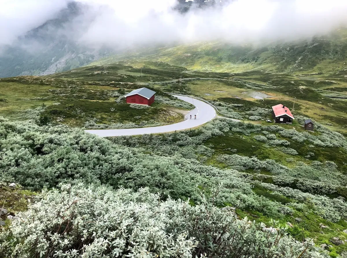
The opening kilometres run flat along the fjord before the gradient bites. Stegastein is signed early. Within a kilometre the road is into proper switchbacks, narrow, with the occasional camper van approaching from above — read the traffic, especially in July and August. We were riding in the COVID summer of 2020 when half of Norway was on a road trip; the wider parts of the road were not as wide as you'd want them to be.

The push to Stegastein is 7.2 kilometres at 7.8% average, with the final kilometre at 10.6%. Brutal is the right word. The Strava segment runs through here, and on the way up we pushed through the parking-lot chaos at the platform without stopping. Tourist cars, buses, panicked reverses. We waved and kept going. Stegastein on the way down — that was the plan.

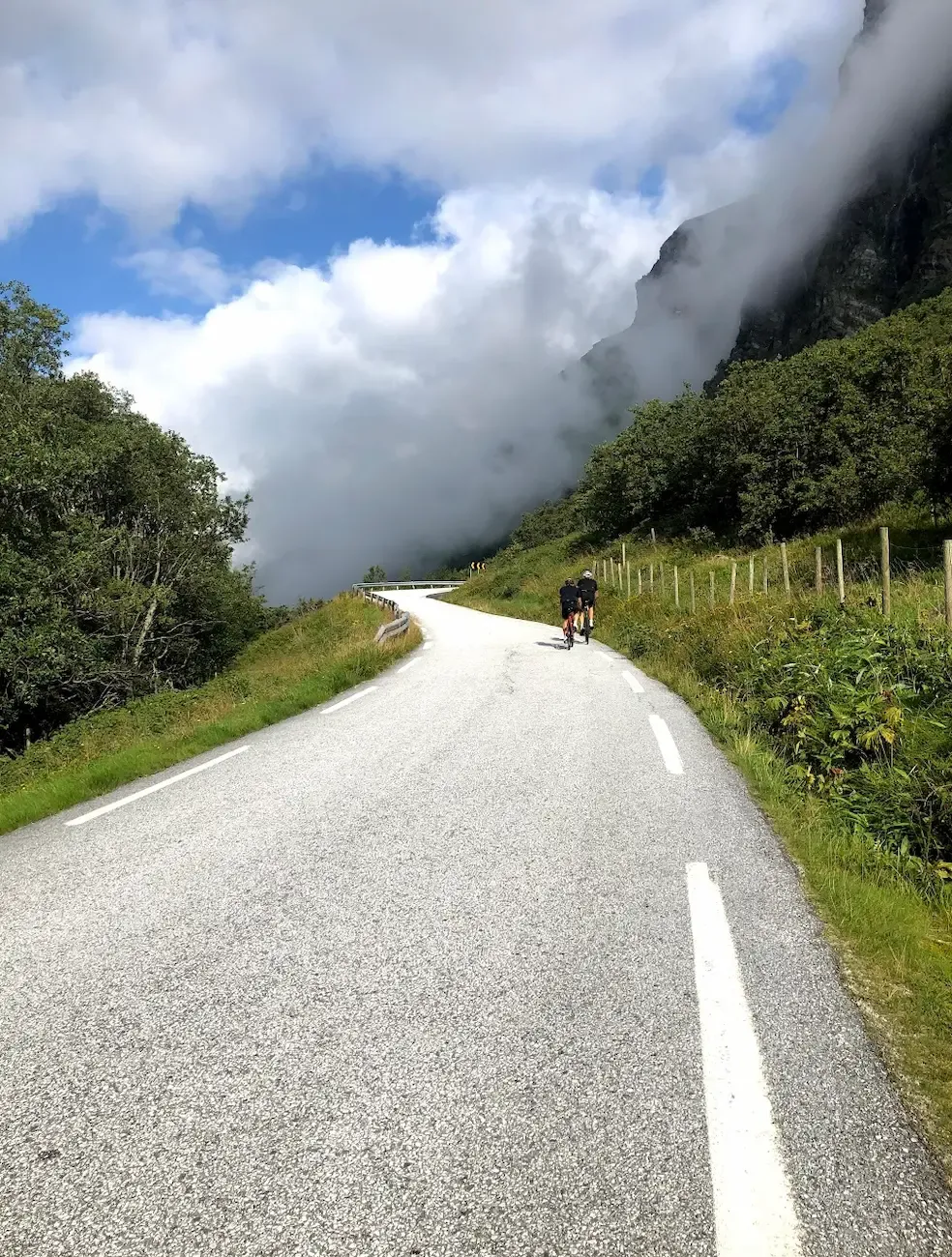
Above the parking lot the climb continues, but the character changes completely. Switchbacks become long straight ramps. The trees give way to bare alpine rock. Sheep stood on the asphalt. A friend was so far ahead I could only see him as a dot. The grade settled around 8% and held there.

Snow patches in August. "Well done" written in chalk on the asphalt near the summit. We stood at the top and said almost nothing for a while.

The descent demanded full attention back through Stegastein — bus traffic dense by midday — and we rolled back into Aurland to a hot shower at Vangsgården (again, just by asking) and a long late lunch at Marianne Bakeri og Kafe at the fjord-side. Pizza, the daily soup, baked goods. We ate until full. The way to close a Norway trip.

Download GPX files

Frequently asked questions

When is the best time for this trip?

Mid-June through mid-September is the climate window. Sognefjellet typically opens in late May to early June depending on snow conditions; Aurlandsfjellet opens around the same time. July and August are warmest and have the longest daylight, but they also bring camper-van traffic on narrow mountain roads. Late June and early September are the quiet sweet spots — passes fully open, fewer tourists, and the light still long enough for 4,000-metre days.

For the full breakdown, see When does Sognefjellet open?

Where should I stay?

Two nights in Skjolden — that's the trip's whole logistical pattern. Arrive Friday afternoon, sleep two nights at the same hotel, ride Saturday and Sunday, then check out Monday morning and drive to Aurland for Day 3 before heading home. No luggage to move, no transfer day. Skjolden has limited accommodation so book early, especially for the July-August window — the village fills with cyclists in peak season.

Do I need a car?

Yes. Day 3 (Aurlandsfjellet) requires a drive from Skjolden to Aurland — the route doesn't connect by bike inside a sensible day. Most cyclists arrive in Norway by air to Bergen or Oslo, then drive 4-5 hours to Skjolden with bikes on roof racks or in the boot. A car also helps with grocery runs, evening logistics and accessing the Mannheller-Fodnes ferry on Day 3.

How fit do I need to be?

Strong. Day 1 is 4,134 metres of climbing in one ride — heavier than most Mallorca or Costa Blanca queen stages. Most cyclists who attempt this trip come with multiple seasons of mountain riding behind them and ride 100-130 km mountain days at home regularly. If 3,000+ metres of climbing in one day is new territory, ride a less aggressive Norwegian trip first — Lom-Sognefjellshytta (out and back to the summit only, ~1,400 m) is a sensible benchmark.

Are the tunnels safe to ride?

Most are, but Day 2 has two completely unlit tunnels on the quiet side of Lustrafjord. Bring proper front and rear lights — not blinky safety LEDs but actual illumination strong enough to see the road surface. We learned this the hard way on our first trip and ended up walking one tunnel single-file with mobile phones as torches. Lights are also legally required for cycling in Norwegian tunnels.

How does this compare to a Mallorca cycling week?

Different sport. Mallorca offers a comfortable hotel base, predictable weather, multiple shop and café options, and queen stages around 2,000-2,400 metres of climbing. This trip has remote logistics, weather windows that can close passes for days, limited services between climbs, and a Day 1 that exceeds a Mallorca queen stage in vertical by almost 70%. Most strong cyclists ride Mallorca first, build experience there, and add Sognefjord as a step up.

For the full breakdown, see Sognefjellet vs Trollstigen — which to ride first

What gearing do I need?

A compact 50/34 chainset with at least an 11-32 cassette is the practical minimum. Stronger climbers run 50/34 with 11-30. The make-or-break ratios are on the upper Tindevegen ramps on Day 1 (long straight gradients in heat) and on the final kilometre to Stegastein on Day 3 (10.6% averaged after 7.8% average for the first six kilometres). On a 4,134-metre Day 1 in 30°C, the gear that lets you stay seated and aerobic for hours is the gear to ride.

Related Western Fjords content

Have you ridden this trip? I'd like to hear how it went — drop me a note.

Send a note